See update below!
Sometimes photographs come to us with no or limited description, leading to a need for some detective work to discover where and when it might have been taken. One example is this recently scanned slide from the Historic Building Survey Photograph Collection (Record Series 1629-01). To view or download a high-resolution image so you can zoom in on details, check out the slide’s catalog record in Digital Collections.
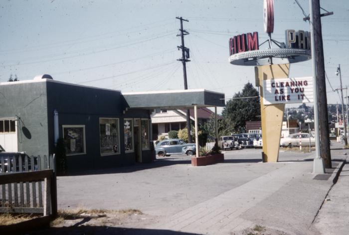
The slide is labeled “Gas station converted to dry cleaner” and has a code of “UR,” which indicates the greater University/Roosevelt area and could potentially be anywhere in northeast Seattle. The date is noted as 1954 but there is no address, specific neighborhood, or business name listed. The lettering on the distinctive sign is not fully visible, and it’s not clear whether the text is the same on both sides or if there are two different words.
It appears that the street going up the right side of the image is an arterial, but it is not clear whether that is also true of the street running left to right behind the building and the street sign is not legible. The visible part of a sign across the street reads “DRIVE” and a hill can be seen in the distance.
Does anyone remember the building or sign, or recognize the location? Notice any other context clues? If you think you might know where this was taken, please email us at archives@seattle.gov and let us know. We will update this post if we solve the mystery!
Update: Thanks to emails and Instagram comments, this has been identified as Pantorium Launderers & Cleaners at 5615 Roosevelt Way. Thanks for your assistance, everyone!